This map was drawn by Professor H. D. Rogers and A. Keith Johnston. It was engraved by W. and A. K. Johnston of Edinburgh, Scotland. This map was copyrighted in both London and Massachusetts in 1857. It measures 14 ½ by 17 7/8 inches. Source: SHSND 978.02 R724t 1857
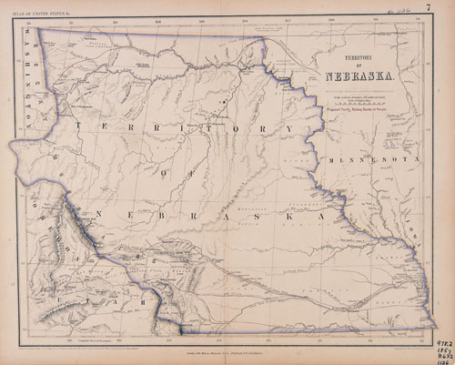
This map shows what is today known as the west river country of North Dakota as part of Nebraska Territory. At this time, the eastern portion of modern day North Dakota was part of Minnesota Territory. In 1858, when Minnesota became a state, the eastern portion of modern North Dakota was left without any territorial status for a couple of years.
(See Unit 3 Document Set 2)
This map includes several proposed routes for transcontinental railroads. In the 1850s railroad technology had improved, California had been admitted to the Union, and many pioneers were undertaking a dangerous six-month long journey to California and Oregon. Railroads could diminish the time, the cost, and the danger of the journey as well as connect California’s gold fields to the eastern states where the gold would be put to use particularly in the growing cities and industries. The purple line that follows the Platte River to South Pass and Bridger’s fort became the route of the Union Pacific Railroad in 1862 (completed in 1869), but in 1858 the sectional quarreling that led to the Civil War prevented Congress from reaching a decision on the route.
Note the line that crosses the northern portion of Nebraska Territory. This roughly anticipates the route of the St. Paul, Minneapolis, and Sault Ste. Marie Railroad (SOO Line) in the early 1880s.
Map Activity: The map includes the term Maison du Chien (house of the dog). We have seen that feature on earlier maps with similar names in English or French. To what feature in the North Dakota landscape does that phrase refer? What is it called today? What feature of the central prairies does the mapmaker refer to with the phrase “good water in numerous ponds?” Why is it important to note that feature on this map? What features are missing which were found on earlier maps?
Address:
612 East Boulevard Ave.
Bismarck, North Dakota 58505
Get Directions
Hours:
State Museum and Store: 8 a.m. - 5 p.m. M-F; Sat. & Sun. 10 a.m. - 5 p.m.
We are closed New Year's Day, Easter, Thanksgiving Day, Christmas Eve, and Christmas Day.
State Archives: 8 a.m. - 4:30 p.m. M-F, except state holidays; 2nd Sat. of each month, 10 a.m. - 4:30 p.m. Appointments are recommended. To schedule an appointment, please contact us at 701.328.2091 or archives@nd.gov.
State Historical Society offices: 8 a.m. - 5 p.m. M-F, except state holidays.
Contact Us:
phone: 701.328.2666
email: history@nd.gov
Social Media:
See all social media accounts