Fort Mandan State Historic Site is temporarily closed for maintenance until further notice.
This map was printed in1924 for the use of travelers in the state. This map measures 38 by 24 inches. Source: SHSND 388.1 N864m 1924
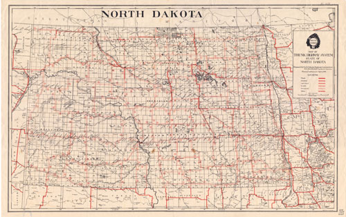
Cars were widely used by 1924, and especially popular with farm families. However, this map indicates the difficulty of traveling around the state, or even from the countryside to town, by automobile in the 1920s. Few roads were paved or graveled. Travel was slow and often impossible when muddy or snow drifted. Drivers had to be prepared to change tires often, perhaps as much as four times between farm and town when the roads were badly rutted.
Map Activity: Read the map key carefully. How many miles of paved roads were available to drivers in 1924? Where were they located? Which of the highway numbers are still in use today? How do North Dakota roads compare to roads in western Minnesota or northern South Dakota?
Address:
612 East Boulevard Ave.
Bismarck, North Dakota 58505
Get Directions
Hours:
State Museum and Store: 8 a.m. - 5 p.m. M-F; Sat. & Sun. 10 a.m. - 5 p.m.
We are closed New Year's Day, Easter, Thanksgiving Day, Christmas Eve, and Christmas Day.
State Archives: 8 a.m. - 4:30 p.m. M-F, except state holidays; 2nd Sat. of each month, 10 a.m. - 4:30 p.m. Appointments are recommended. To schedule an appointment, please contact us at 701.328.2091 or archives@nd.gov.
State Historical Society offices: 8 a.m. - 5 p.m. M-F, except state holidays.
Contact Us:
phone: 701.328.2666
email: history@nd.gov
Social Media:
See all social media accounts