We’ve launched a new web portal! Visit findhistory.nd.gov to search our collections.
Due to a road closure, the Killdeer Mountain Battlefield State Historic Site
is temporarily closed.

Subscribe to SHSND podcasts
Located approximately 30 miles south of Mandan, ND.
Parking space is available, but there are no visitor services. There is a marker on the site.
No Rental Facilities
Free admission, donations welcome.
No Related Links
Fort Rice was established on July 7, 1864, by General Alfred H. Sully as a field base during his 1864 expedition. The fort was named for Brigadier General James Clay Rice of Massachusetts who was killed at the Battle of the Wilderness during the Civil War. Fort Rice was the first of a chain of forts intended to guard northern plains transportation routes, evidence of the United States government’s changing policy toward these western lands, encouraging their settlement and providing protection for Euro-American settlers. Fort Rice became one of the most important military posts on the Upper Missouri River. It is located approximately thirty miles south of Mandan, Morton County.
During the summer of 1864, Sioux in Dakota Territory were angered by the military expeditions that had attacked Dakota, Lakota, and Yanktonai bands the previous year. In response, the Indians increased their attacks on northern plains transportation routes, including steamboats traveling on the Upper Missouri.
In 1864 General Sully returned to the Upper Missouri with an army of 3,500 men to punish the Sioux, to force them onto reservations, and to strengthen the peace by building military forts near the mouth of Long Lake Creek (Fort Rice), at the confluence of the Yellowstone and Missouri Rivers (eventually Fort Buford), and near the mouth of the Powder River. The army hired fifteen steamboats to transport men and supplies part of the distance and retained three steamboats to support the expedition for its four-month duration.
Sully’s first action was to select a location for Fort Rice. The military reservation for the fort covered approximately 175 square miles (112,000 acres) and was established by Executive Orders of September 2, 1864, and January 22, 1867. The first structures were built by several companies of the 30th Wisconsin Infantry under Colonel Daniel J. Dill. Cottonwood logs, cut from the wooded banks of the Missouri River, formed the stockade, 510 feet by 500 feet. Two log blockhouses, each twenty feet square, guarded the northeast and the southwest corners of the stockade. The fort buildings inside the stockade were built with cottonwood logs and had sod roofs.
In the autumn of 1864, six companies of the 1st US Volunteer Infantry arrived to replace the Wisconsin infantry. The “volunteers” were primarily Confederate prisoners of war, or so-called Galvanized Yankees. These prisoners enlisted in the Union Army to protect the western frontier rather than wait to be paroled or exchanged for Yankee prisoners of war or be sent north to work on government fortifications. Two companies of the similarly organized 4th US Volunteers arrived as reinforcements in 1865. Upon the disbandment of the US Volunteers, these units were replaced by Union volunteer troops (state militia) and after the war by troops of the “regular” army.
Life was not easy in these small frontier forts, isolated by distance and a seasonally ice-bound transportation system. During the fort’s first year, eighty-one men died—thirty-seven from scurvy, twenty-four from chronic diarrhea, three of typhoid fever, ten of other diseases, and seven killed in combat. To pass the time during the first winter, the soldiers opened a theater, and from June 15 through October 9, 1865, they published their own newspaper, the Frontier Scout.
Throughout its existence, Fort Rice was a highly active military post. It served as base of operations for General Sully’s First and Second Northwestern Expeditions of 1864 and 1865. In 1866-1868, important Indian councils were held at the post. The most important of these was the Great Council with various Sioux bands in July 1868. Although a key leader of the Lakota, Tȟatȟáŋka Íyotake(Sitting Bull), refused to participate, Father Pierre Jean De Smet did convince Sitting Bull to allow his chief lieutenant, Phizí (Gall), to attend this council. As a result of this council, area Sioux bands signed the Fort Laramie Treaty of 1868, which ended the Red Cloud War and defined the boundaries of the Great Sioux Reservation. The reservation included most of the area west of the Missouri River in present-day South Dakota.
In 1868 Fort Rice was expanded to cover an area of 864 feet by 544 feet. It was protected by a ten-foot-high log stockade on three sides and by the Missouri River on the east. Within the stockade and surrounding the parade ground were four company barracks with kitchens, seven officers’ quarters, a post hospital, bakery, storehouses, library, and a powder magazine. Outside the east line of buildings were the guardhouse and post headquarters. Various other buildings stood between these buildings and the stockade, such as company sinks (privies), laundress quarters, and bathhouse. Outside the stockade were the stables, barns, corrals, blacksmith shop, Indian scouts’ quarters, and the post-trader’s store.
The new barracks were made of pine lumber, but all other buildings were built from locally sawn cottonwood boards. Some were insulated with homemade adobe bricks stacked between the wall studs. Clapboard siding and shingled roofs completed the improvements.
Although the fort was designed for four companies of infantry, it was later modified to accommodate several companies of the 7th US Cavalry. While the average garrison was 235 men, troops ranged from a high of 357 in 1874 to a low of 61 in 1878. Throughout the history of the fort, the soldiers guarded against Indian attacks. Warriors assaulted haying and logging parties and raided the horse and cattle herds of the army and of civilian traders. These raids continued as late as 1877.
Between 1871 and 1873, Fort Rice served as the base for the First, Second, and Third Yellowstone expeditions, which escorted parties surveying the route of the Northern Pacific Railroad. Four companies of the Fort Rice contingent of the 7th Cavalry accompanied Lieutenant Colonel George A. Custer on his Black Hills expedition in 1874. Two companies from Fort Rice fought in the Battle of the Little Bighorn.
The post was abandoned on November 25, 1878, after the establishment of Fort Yates on the Standing Rock Agency. In 1913 the State of North Dakota acquired Fort Rice, and in the 1940s, the Works Progress Administration (WPA) marked the foundations of many of the Fort Rice buildings.
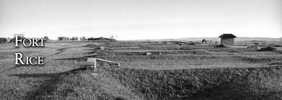
None of the original buildings or structures remain at Fort Rice. Visitors will see depressions, foundation lines, and WPA corner markers. A brief history of the fort and a map appear on a site marker. Parking space is available, but there are no visitor services.
SHSND Address:
612 East Boulevard Ave.
Bismarck, North Dakota 58505
Get Directions
SHSND Hours:
Museum Store: 8am - 5pm M-F; Sat. & Sun. 10am - 5pm.
State Archives: 8am - 4:30pm., M-F, except state holidays, and 2nd Sat. of each month, 10am - 4:30 pm.
State Historical Society offices: 8am - 5pm M-F, except state holidays.
Contact SHSND:
phone: 701.328.2666
email: history@nd.gov