We’ve launched a new web portal! Visit findhistory.nd.gov to search our collections.
Due to a road closure, the Killdeer Mountain Battlefield State Historic Site
is temporarily closed.

Subscribe to SHSND podcasts
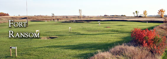
Located southwest of the town of Fort Ransom, ND.
Building remnants and cellars, a fortification ditch with an embankment, a flagpole, a marker describing the military fort, and a parking area on the east side of a county road.
No Rental Facilities
Free admission, donations welcome.
No Related Links
Fort Ransom, established in 1867 to protect overland travel from Minnesota to Montana, was named in honor of brevet Major General Thomas E. G. Ransom of the US Volunteers. Today, although the building locations and the dry moat are still clearly discernible, nothing else remains of the original fort or its twelve-foot high sod and log stockade. The historic site is located southwest of the town of Fort Ransom, Ransom County.
On June 17, 1867, a battalion of the 10th US Infantry, commanded by brevet Major George H. Crosman, arrived from Fort Wadsworth in southern Dakota Territory. Soldiers began work on enclosing a breastwork and completed it by August. Oak logs from the nearby Sheyenne River Valley were used to construct the post. The buildings were arranged within the earthen breastworks in a square, measuring 350 by 400 feet. Ten square miles around the fort were designated as Fort Ransom Military Reservation, Dakota Territory.
With the exception of two, all were one-story log buildings. The barracks building was under one roof on the north side of the square and was subdivided into four large rooms for the enlisted men and two small rooms for the first sergeants. Box stoves warmed quarters, and each squad room had three windows. Kitchens were attached to the rear of the quarters. Other buildings at the post were quartermaster and commissary storehouses, quarters for married men, a granary, bakery, guardhouse, hospital, office for commandant and adjutant, stables, and the magazine. Outside the breastworks were quarters for the Indian scouts.
Survival at this military post, like any frontier settlement, was a constant struggle. Water for drinking and cooking had to be hauled from a spring 600 yards away. Facilities for bathing at the post were limited, and the nearby river was used for that purpose during the summer. The vegetable garden, eight acres in size, was near the post, and hay for livestock was harvested three miles to the south.
Quartermaster teams linked Fort Abercrombie to Fort Ransom, and a tri-weekly coach ran to St. Cloud, Minnesota. In winter the route from Fort Ransom to Fort Abercrombie was particularly dangerous due to storms, and in spring, flooding on the Wild Rice River stopped communication. In good weather the weekly mail by horseback via Fort Abercrombie took eight days to reach St. Paul, Minnesota.
Fort Ransom was dismantled in 1872, and the materials were used to build Fort Seward at Jamestown, Stutsman County. The army had determined that protection of the Northern Pacific Railroad crew at the James River crossing was a higher priority than protecting the overland route. The final disposition of the military reservation took place on July 14, 1880, when it was turned over to the Department of the Interior for survey and sale to homesteaders.
Today a marker describing the military fort sits beside a parking area on the east side of a county road. Building remnants and cellars, a fortification ditch with an embankment, and a flagpole mark the remains of this once thriving post.
SHSND Address:
612 East Boulevard Ave.
Bismarck, North Dakota 58505
Get Directions
SHSND Hours:
Museum Store: 8am - 5pm M-F; Sat. & Sun. 10am - 5pm.
State Archives: 8am - 4:30pm., M-F, except state holidays, and 2nd Sat. of each month, 10am - 4:30 pm.
State Historical Society offices: 8am - 5pm M-F, except state holidays.
Contact SHSND:
phone: 701.328.2666
email: history@nd.gov